Local Government
South Perth
Region
Metropolitan
Perth & South Perth
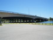
Bridge No 953
South Perth
Metropolitan
Constructed from 1959
| Type | Status | Date | Documents |
|---|---|---|---|
| Heritage List | Adopted | 25 Sep 2018 | |
| State Register | Registered | 23 Apr 1999 | HCWebsite.Listing+ListingDocument, HCWebsite.Listing+ListingDocument |
| Type | Status | Date | Documents |
|---|---|---|---|
| (no listings) |
| Type | Status | Date | Grading/Management | |
|---|---|---|---|---|
| Category | ||||
| Local Heritage Survey | Adopted | 13 Mar 2001 | Category A | |
| Perth Draft Inventory 99-01 | YES | 31 Dec 1999 | ||
| Name | Type | Year From | Year To |
|---|---|---|---|
| Sir W Holford & Partners, UK | Architect | - | - |
| Library Id | Title | Medium | Year Of Publication |
|---|---|---|---|
| 6752 | South Perth : the vanishing village. | Book | 2003 |
| 8788 | New MetroRail : southern suburbs railway. Operations noise and vibration management plan Narrows Bridge to Perth Rail Yard. DRAFT for stakeholder comment. | Report | 2007 |
| 7759 | Guide to heritage bridge management. | Book | 2001 |
| 8711 | From the wastelands. | Journal article | 2001 |
| 9212 | Mitchell Freeway Stage 1: National engineering landmark award unveiling ceremony. | Brochure | 2008 |
| 4899 | Narrows Bridge : conservation plan. | Heritage Study {Cons'n Plan} | 1998 |
Historic site
| Epoch | General | Specific |
|---|---|---|
| Original Use | Transport\Communications | Road: Bridge |
| Present Use | Transport\Communications | Road: Bridge |
| Style |
|---|
| Other Style |
| Type | General | Specific |
|---|---|---|
| Wall | CONCRETE | Reinforced Concrete |
| General | Specific |
|---|---|
| TRANSPORT & COMMUNICATIONS | Road transport |
This information is provided voluntarily as a public service. The information provided is made available in good faith and is derived from sources believed to be reliable and accurate. However, the information is provided solely on the basis that readers will be responsible for making their own assessment of the matters discussed herein and are advised to verify all relevant representations, statements and information.
Constructed from 1959
The following statement is drawn from the State Register Entry for Place 4795 narrows Bridge, prepared in 1999. (It does not include reference to the railway line or second bridge built in 2001) Narrows Bridge, a five span pre-stressed concrete bridge, has cultural heritage significance for the following reasons: • the place is a strong landmark element of the visual landscape which comprises the built form of the City and the Narrows Bridge and the natural form of the river and Mt Eliza, this same visual resolution is apparent during the day and at night time in the context of an illuminated City and Bridge; • the place is the first physical manifestation of the Hepburn and Stephenson plan, which contributed to the development of the Freeway road systems in the State and the Perth Metropolitan Region Scheme from the 1950s; • the pre-stressed concrete structure is representative of innovative engineering technology and method developed in the 1950s. The construction involved structural design, techniques and materials appropriate to a low-profile structure in a visually, critical location with difficult foundation characteristics; • the place has associations with eminent consulting engineers, Maunsell & Partners in the U.K. and consulting architects, Sir William Holford and Partners in the U.K., as an element of the Stephenson-Hepburn Report of the 1950s which emphasised the need for aesthetic consideration to be incorporated into the design of the Bridge; and, • the place contributes to the community's sense of place as an element in the landscape of the City.
The Narrows Bridge comprises three separate structures which appear to form one single bridge. The original road bridge (1959) is the eastern span which provided six lane vehicle access and pedestrian walkways either side. The western section (2001) was constructed six metres to the west of the original section and is of similar pre-cast concrete construction. The central section comprises the railway bridge which was constructed in 2007. The three separate structures are evident from underneath with narrow slithers of light filtering through either side of the railway bridge. From above, the bridge provides a more unified picture and creates the appearance of a single structure. The original 335 metre long pre-stressed concrete road bridge, said to be the largest of its type in the world when it was constructed, is built on hollow steel cylinders filled with reinforced concrete and driven about 34 metres below the river’s surface. The original six-lane Narrows Bridge, on foundations sunk into reclaimed mud flats, is fixed at its northern end and rolls on ball bearings at its southern end to cope with expansion. The construction involved innovative engineering technology at the time, and utilised structural design, techniques and materials appropriate to a structure required to be low-profile in a visually critical location, with difficult foundation characteristics. The second road bridge, constructed in 2001, closely follows the design of the original bridge. The railway bridge, centred between the two road bridges, is almost undiscernible from a distance, apart from some vertical infrastructure at intervals along the bridge. At night, the bridges are illuminated, making the Narrows Bridge a prominent landmark at all times. Due to its prominent position across the Swan River, the Narrows Bridge is a strong landmark element of the landscape in views along Mounts Bay Road and Riverside Drive to the north of the River and South Perth Esplanade to the south of the river.
This information is largely drawn from the Heritage Council of WA Assessment prepared in July 1998. The Narrows Bridge was built in 1959. Discussions about how to bridge the narrow neck in the river, known as ‘the Narrows’, between Perth Water and Melville Water, first took place in the 1840s. However, priority was given to a causeway to the east of the Perth CBD, which was opened to traffic in May 1843. The first means of crossing from Point Belches to the foot of Mt Eliza, the closest point, was via a pole punt carrying horses, riders and cargo from 1833. Throughout the first half of the 20th century, the issue of a bridge across the Narrows caused division within both the South Perth Council and the community. Local residents objected on the grounds that it would spoil the view to and from the city. Direct road access to South Perth from the CBD was favoured by land and property developers, but was resisted by those who wanted South Perth to retain its quiet residential character although many of the South Perth residents were daily commuters between the peninsula and the City of Perth. The ferry and tram system was a constant source of dissatisfaction among the commuters. By 1935, a Road Board publication referred to the bridge as inevitable and from about 1952 onward, the pressure for a bridge became really intense. Largely as a result of the Stephenson-Hepburn Report released in 1955, a decision was made at State Government level to proceed with the construction of a bridge. In 1955, eminent consulting engineers, Maunsell and Partners of London and Melbourne, were appointed consulting engineers. Also involved were consulting architects, Sir William Holford and partners in the UK. In March 1957 a tender of £1,700,000 ($3,400,000) was accepted from Christiani and Nielson, in association with J O Clough & Son (Pty) Ltd of Perth. Construction of the bridge began in 1956 and involved reshaping Point Belches and taking about 200 feet (61 metres) off the shoreline, reclaiming a controversially large extent of Perth Water and changing the character of the view of Perth from Mt Eliza. At one stage, the name of the new bridge was to be the ‘Golden West Bridge’, but this decision was later reversed, and the Narrows Bridge was officially opened on Friday 13 November 1959. The Narrows Bridge included entry and exit ramps at South Perth near the tip of the peninsula. Initially, the entry from South Perth onto the freeway was in the form of a loop road under the Bridge via South Perth Esplanade; and the exit from the freeway into South Perth was a simple ramp that connected to the northern end of Mill Point Road. However, by 1967, congestion caused traffic movements to be re-examined. The local roads were modified to close the original entry ramp and create new north- and south-bound entry ramps and a south-bound exit ramp at Judd Street, while also modifying the north-bound exit ramp at the tip of the peninsula. From the 1970s, owing to an increase in traffic volumes and congestion across the bridge, plans were floated for a second bridge alongside the original Narrows Bridge. A decision to build a second bridge was approved in 1998 and work began by Leighton Contractors on the duplicate bridge in May 1999. The new bridge is situated 6 metres west of the original bridge. In October 2001, the second road bridge replicating the design of the first, opened alongside the original Narrows Bridge. The new bridge was designed to carry north-bound traffic, doubling the capacity of the original 3 x 3 lane bridge and including a dedicated bus lane on each bridge. The construction was achieved without the need to widen the existing freeway reserve, or undertake further reclamation of the river. Considerable renovations to the original bridge were also undertaken as part of this work. In 2005, further construction work commenced on the dual Narrows Bridge to accommodate a two-way railway line. This was part of a new railway line located between the opposing traffic lanes of the Kwinana Freeway; and extending from the Perth central business district to Mandurah. The work on both bridges was completed in 2007, accommodating south-bound lines on a new railway bridge constructed in the 6.0 metre gap between the two road bridges. The north-bound tracks are laid on the north-bound (western) road bridge which opened in 2001.
High / High
Good
| Name | Type | Year From | Year To |
|---|---|---|---|
| Sir W. Holford & Partners, UK | Architect | - | - |
| Ref ID No | Ref Name | Ref Source | Ref Date |
|---|---|---|---|
| Florey, Cecil. "Peninsular City: A Social History of the City of South Perth" | City of South Perth | 1995 |
| Reserve | Lot/Location | Plan/Diagram | Vol/Folio |
|---|---|---|---|
| 33804 | 13017 | 193785 | LR3026-703 |
| 37594 | 301 | 47451 | LR3151-548 |
This information is provided voluntarily as a public service. The information provided is made available in good faith and is derived from sources believed to be reliable and accurate. However, the information is provided solely on the basis that readers will be responsible for making their own assessment of the matters discussed herein and are advised to verify all relevant representations, statements and information.
South Perth
South Perth
Metropolitan
| Type | Status | Date | Documents |
|---|---|---|---|
| (no listings) |
| Type | Status | Date | Documents |
|---|---|---|---|
| (no listings) |
| Type | Status | Date | Grading/Management | |
|---|---|---|---|---|
| Category | ||||
| Municipal Inventory | Adopted | 28 Feb 1996 | Category E | |
Historic Site
| Epoch | General | Specific |
|---|---|---|
| Original Use | Transport\Communications | Road: Other |
| Present Use | Transport\Communications | Road: Other |
| General | Specific |
|---|---|
| TRANSPORT & COMMUNICATIONS | Rail & light rail transport |
This information is provided voluntarily as a public service. The information provided is made available in good faith and is derived from sources believed to be reliable and accurate. However, the information is provided solely on the basis that readers will be responsible for making their own assessment of the matters discussed herein and are advised to verify all relevant representations, statements and information.
Site
This information is provided voluntarily as a public service. The information provided is made available in good faith and is derived from sources believed to be reliable and accurate. However, the information is provided solely on the basis that readers will be responsible for making their own assessment of the matters discussed herein and are advised to verify all relevant representations, statements and information.
Cnr Angelo & Forrest Sts South Perth
South Perth
Metropolitan
| Type | Status | Date | Documents |
|---|---|---|---|
| (no listings) |
| Type | Status | Date | Documents |
|---|---|---|---|
| (no listings) |
| Type | Status | Date | Grading/Management | |
|---|---|---|---|---|
| Category | ||||
| (no listings) | ||||
Individual Building or Group
| Epoch | General | Specific |
|---|---|---|
| Original Use | EDUCATIONAL | Housing or Quarters |
| Present Use | EDUCATIONAL | Primary School |
This information is provided voluntarily as a public service. The information provided is made available in good faith and is derived from sources believed to be reliable and accurate. However, the information is provided solely on the basis that readers will be responsible for making their own assessment of the matters discussed herein and are advised to verify all relevant representations, statements and information.
This information is provided voluntarily as a public service. The information provided is made available in good faith and is derived from sources believed to be reliable and accurate. However, the information is provided solely on the basis that readers will be responsible for making their own assessment of the matters discussed herein and are advised to verify all relevant representations, statements and information.
Cnr Angelo & Sandgate Sts South Perth
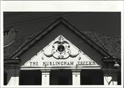
Uniting Church Hall
South Perth
Metropolitan
Constructed from 1925
| Type | Status | Date | Documents |
|---|---|---|---|
| (no listings) |
| Type | Status | Date | Documents |
|---|---|---|---|
| RHP - Does not warrant assessment | Current | 27 Feb 2004 |
| Type | Status | Date | Grading/Management | |
|---|---|---|---|---|
| Category | ||||
| Uniting Church Inventory | Completed | 01 Oct 1996 | ||
Individual Building or Group
| Epoch | General | Specific |
|---|---|---|
| Original Use | RELIGIOUS | Church, Cathedral or Chapel |
| Present Use | RELIGIOUS | Church, Cathedral or Chapel |
| Type | General | Specific |
|---|---|---|
| Roof | TILE | Ceramic Tile |
| Wall | BRICK | Common Brick |
| General | Specific |
|---|---|
| SOCIAL & CIVIC ACTIVITIES | Religion |
This information is provided voluntarily as a public service. The information provided is made available in good faith and is derived from sources believed to be reliable and accurate. However, the information is provided solely on the basis that readers will be responsible for making their own assessment of the matters discussed herein and are advised to verify all relevant representations, statements and information.
57 Angelo St South Perth
Cnr Labouchere Rd
25 Pounder Cannon
South Perth
Metropolitan
Constructed from 1942
| Type | Status | Date | Documents |
|---|---|---|---|
| Heritage List | Adopted | 25 Sep 2018 |
| Type | Status | Date | Documents |
|---|---|---|---|
| (no listings) |
| Type | Status | Date | Grading/Management | |
|---|---|---|---|---|
| Category | ||||
| Municipal Inventory | Adopted | 14 Nov 2000 | Category B | |
Other Built Type
| Epoch | General | Specific |
|---|---|---|
| Present Use | MONUMENT\CEMETERY | Monument |
| Original Use | MILITARY | Other |
| Type | General | Specific |
|---|---|---|
| Other | METAL | Other Metal |
| General | Specific |
|---|---|
| OUTSIDE INFLUENCES | World Wars & other wars |
This information is provided voluntarily as a public service. The information provided is made available in good faith and is derived from sources believed to be reliable and accurate. However, the information is provided solely on the basis that readers will be responsible for making their own assessment of the matters discussed herein and are advised to verify all relevant representations, statements and information.
Constructed from 1924
• The place has aesthetic value as a prominent and distinctive landmark in the streetscape since 1962. • The place has historic value for its association with the Returned Services League who provide services and support for ex-service men, women and their families. • The place has social value for the many members of the community who recognise the gun as a memorial to those who served during World War Two. • The Field gun has some research value for students of weaponry.
The immobilised Quick Firing 25-pounder Field Gun Howitzer Mark I Field Gun is situated on the footpath outside the South Perth Sub-Branch of the Returned and Services League. It is mounted on a on a Mark II Carriage.
This Field Gun is a Quick Firing 25-pounder Field Gun Howitzer Mark I (on a Mark II Carriage), built in 1942. The 25-pounder was the main field artillery weapon used by British Commonwealth and colonial infantry and armoured divisions of all types during World War II (1939-1945). This type of weapon was introduced into service just before the war started, combining high-angle and direct-fire, relatively high rates of fire, and a reasonably lethal shell in a highly mobile piece. It remained the British Army's primary artillery field piece well into the 1960s. The Field Gun was placed outside the South Perth Sub-Branch of the Returned and Services League (RSL) Hall in Angelo Street in April 1962 as a memorial to the World War II Gunners who lost their lives during the conflict. The placement of the gun was organised by Jim Walmsley (c1909-1993), President of this Sub-Branch in the 1960s. Walmsley was a member of the Artillery during World War II. In 2010, the Field Gun was restored and repainted by the Royal Australian Artillery Historical Society. In 2018, the Field Gun was relocated to Ernest Johnson Oval. This decision was made in part due to the RSL relocating to a new facility at the same location.
Moderate
Good
| Ref ID No | Ref Name | Ref Source | Ref Date |
|---|---|---|---|
| Interview with Kevin Trent (President of South Perth RSL) | Conducted by Cathy Day "heritage Today" | 20/5/1999 |
| Owner | Category |
|---|---|
| South Perth Sub-Branch RSL | Other Private |
This information is provided voluntarily as a public service. The information provided is made available in good faith and is derived from sources believed to be reliable and accurate. However, the information is provided solely on the basis that readers will be responsible for making their own assessment of the matters discussed herein and are advised to verify all relevant representations, statements and information.
57 Angelo St South Perth
South Perth
Metropolitan
Constructed from 1961
| Type | Status | Date | Documents |
|---|---|---|---|
| (no listings) |
| Type | Status | Date | Documents |
|---|---|---|---|
| (no listings) |
| Type | Status | Date | Grading/Management | |
|---|---|---|---|---|
| Category | ||||
| Local Heritage Survey | Adopted | 14 Nov 2000 | Category C | |
Historic Site
| Epoch | General | Specific |
|---|---|---|
| Original Use | SOCIAL\RECREATIONAL | RSL Hall |
| Present Use | SOCIAL\RECREATIONAL | RSL Hall |
| Style |
|---|
| Post-War International |
| Type | General | Specific |
|---|---|---|
| Wall | BRICK | Painted Brick |
| Wall | BRICK | Common Brick |
| Roof | METAL | Corrugated Iron |
| Wall | BRICK | Rendered Brick |
| General | Specific |
|---|---|
| SOCIAL & CIVIC ACTIVITIES | Cultural activities |
This information is provided voluntarily as a public service. The information provided is made available in good faith and is derived from sources believed to be reliable and accurate. However, the information is provided solely on the basis that readers will be responsible for making their own assessment of the matters discussed herein and are advised to verify all relevant representations, statements and information.
Constructed from 1961
• The place has aesthetic value as a good intact example of the post war international style executed in brick, stone and metal. • The place has aesthetic value as a prominent element in the streetscape since 1961. • The place has historic value for its association with the Returned Services League who provide services and support for ex-service men, women and their families. • The place has social value for the many members of the community who have attended events at the premises.
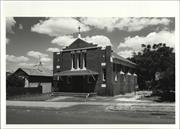
The South Perth Sub-Branch returned and Services League Hall is located on a corner plot at the intersection of Angelo Street and Anstey Street. the diminutive single storey building is somewhat over-dominated by the adjacent Post Office building in the Angelo Street street scene but due to its angled entrance, and feature stone wall, the RSL Hall does manage to make an impression. The Hall is of single storey construction utilising a wide palette of materials including brick, stone and render. The façade is formed by the angled corner elevation overlooking the intersection of Angelo and Anstey Streets. The entry door is set back behind a covered porch with concrete deck and rendered walls. The Angelo Street elevation is dominated by the random stone wall which incorporates the building name “RSL HALL” and emblem. This section of stone wall connects the utilitarian brick section of elevation and the angled entry feature. A narrow strip of high level timber framed windows extends across the brick section of elevation. The rear section of the building, seen along Anstey Street, is of pale brick construction with randomly placed dark bricks and a dark brick plinth and a single timber framed window. The roof is very shallow mono-pitched clad corrugated metal, the profile of which can be seen from Anstey Street.
The Returned and Services League Australia (RSL), Western Australian Branch, was formed in 1916 to represent and look after the interests, welfare, and well-being of returned (military) servicemen and women. Veterans of World War I (1914-1918) formed the South Perth Sub-Branch of the RSL on 16 December 1919. Initially, the South Perth Sub-Branch met in rented accommodation, mainly in the (former) Swan Street Hall. Following World War II (1939-1945), the City of South Perth provided the Sub-Branch with the block of land on the corner of Angelo and Anstey Streets in South Perth. The South Perth Sub-Branch Returned and Services League Hall was built following a fundraising drive under the direction of Jim Walmsley (c1909-1993), President of this Sub-Branch. William S Lonnie CBE, MVO, MC, State President of the RSL, opened the Hall on 9 December 1961. The Hall cost £5,500 to construct. Under Jim Walmsley’s direction, the RSL also acquired the Field Gun situated outside the hall. Since its inception, the South Perth Sub-Branch Returned and Services League Hall has been used as a venue for Sub-Branch meetings and, until the late 1970s, was also used for dances and social functions. From the late 1970s portion of the hall has been used as a commercial tenancy. In 2018, Sub-Branch meetings were moved from the Hall to a new facility at Ernest Johnson Oval.
High / High
Good
| Ref ID No | Ref Name | Ref Source | Ref Date |
|---|---|---|---|
| Interview with Kevin Trent (President of South Perth RSL) | Conducted by Cathy Day "heritage Today" | 20/5/1999 |
| Reserve | Lot/Location | Plan/Diagram | Vol/Folio |
|---|---|---|---|
| 747 | 161127 | 1905-63 |
| Owner | Category |
|---|---|
| South Perth Sub-Branch RSL | Other Private |
This information is provided voluntarily as a public service. The information provided is made available in good faith and is derived from sources believed to be reliable and accurate. However, the information is provided solely on the basis that readers will be responsible for making their own assessment of the matters discussed herein and are advised to verify all relevant representations, statements and information.
59 Angelo St South Perth
South Perth
Metropolitan
Constructed from 1939
| Type | Status | Date | Documents |
|---|---|---|---|
| Heritage List | Adopted | 25 Sep 2018 |
| Type | Status | Date | Documents |
|---|---|---|---|
| RHP - To be assessed | Current | 27 Feb 2004 |
| Type | Status | Date | Grading/Management | |
|---|---|---|---|---|
| Category | ||||
| Local Heritage Survey | Adopted | 14 Nov 2000 | Category B | |
| Art Deco Significant Bldg Survey | Completed | 30 Jun 1994 | ||
Individual Building or Group
| Epoch | General | Specific |
|---|---|---|
| Present Use | Transport\Communications | Comms: Post or Telegraph Office |
| Original Use | Transport\Communications | Comms: Housing or Quarters |
| Original Use | Transport\Communications | Comms: Post or Telegraph Office |
| Style |
|---|
| Inter-War Stripped Classical |
| Type | General | Specific |
|---|---|---|
| Wall | CONCRETE | Reinforced Concrete |
| Roof | TILE | Terracotta Tile |
| General | Specific |
|---|---|
| TRANSPORT & COMMUNICATIONS | Mail services |
| TRANSPORT & COMMUNICATIONS | Telecommunications |
This information is provided voluntarily as a public service. The information provided is made available in good faith and is derived from sources believed to be reliable and accurate. However, the information is provided solely on the basis that readers will be responsible for making their own assessment of the matters discussed herein and are advised to verify all relevant representations, statements and information.
Constructed from 1939
• The place has aesthetic value as a large, intact example of the Inter War Stripped Classical style in brick and tile. Internal details that remain from the original construction are likely to reflect this style • The place has historic value as a demonstration of the investment by the Commonwealth Government in the provision of telephones to the suburbs of Australia. • The place has historic value for its demonstration of the growth of South Perth in the Inter War period though the provision of services to the growing community. • The place has social value for the local community as it has provided a continuity of service and presence in the streetscape since 1939.
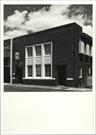
The Angelo Street Post Office is situated in the retail/commercial strip near the intersection of Angelo Street and Coode Street. Originally constructed as a standalone building the adjoining telephone exchange was added in the 1960s which impacted on the symmetry and individuality of the building. The Angelo Street Post Office is a two storey structure, with increased height due to the parapet walls. The structure is constructed of reinforced concrete with a red and dark brown coloured pressed brick patterned façade. The original section of the building has a symmetrical façade but following the construction of the telephone exchange, the façade became unbalanced. The two sections of the building are roofed with a single hipped form clad with terracotta tiles. The main face of the post office building is red brick set one course behind the plinth. The main face is framed with brown-coloured bricks set back one course with a herringbone pattern and soldier brick frieze to the parapet. The plinth to dado height is rusticated with unbonded brown header bricks. The dark brown bricks are carried around the reveal linings of the door openings, recessed in three steps. The door openings are protected by wrought iron grilles, which are notable for their design. The centre of the main façade to the Post Office section is dominated by a pre-cast, pressed cement panel containing six metal framed windows. The upper level windows are each 10 paned openings whilst the ground level windows are 12 panes each. Although the pane size is different, the windows are of similar design. The central panel is decorated with vertical fluting mullions and a chequerboard pattern to the panels between the two levels of windows. The adjoining telephone exchange section of the building replicates the scale and massing of the Post Office but the design is completely different. The material palette reflects that of the adjoining building with the majority constructed in red brick enlivened by rendered columns. The telephone exchange is divided into two unequal sections with vehicular access through the western bay. The lower section of the façade is set back behind the upper level, creating a narrow shaded area. The upper level contains five metal framed windows, forming a continuous band across the façade.
This building was constructed in 1939 by local contractors Angell and Clark to a design prepared by the Commonwealth Department of the Interior for the Post Master Generals Department. The successful tender of £5500 was awarded in December 1938 and the firm undertook the construction quickly in the first half of the year as the building was opened for business on 10 July 1939 as the Post Office, South Perth. The former post office in Mends Street was renamed the Mends Street Post Office, South Perth. The building provided postal and telegraph services and originally had living quarters but these rooms were allocated to other functions when staff were no longer required to attend at all hours. The building has been upgraded and altered over the years to suit changing technologies. Major changes occurred in the early 1960s, c1980 and in 2015. It continues to be used as a Post Office for the descendant organisation, Australia Post.
High / High
Good
| Ref ID No | Ref Name | Ref Source | Ref Date |
|---|---|---|---|
| Pope,B. Bush, F. Broomfield, W. & Kelsall, D.M. " Historical Architectural Assessment of Post Offices in Western Australia as at 21 July 1991" | National Trust of Australia (WA) | 1993 |
| Reserve | Lot/Location | Plan/Diagram | Vol/Folio |
|---|---|---|---|
| 123 | 15257 | 1808-946 |
| Owner | Category |
|---|---|
| Australian Telecommunications Commissoin | Commonwealth Gov't |
This information is provided voluntarily as a public service. The information provided is made available in good faith and is derived from sources believed to be reliable and accurate. However, the information is provided solely on the basis that readers will be responsible for making their own assessment of the matters discussed herein and are advised to verify all relevant representations, statements and information.
65 Angelo St South Perth
South Perth
Metropolitan
Constructed from 1926
| Type | Status | Date | Documents |
|---|---|---|---|
| (no listings) |
| Type | Status | Date | Documents |
|---|---|---|---|
| (no listings) |
| Type | Status | Date | Grading/Management | |
|---|---|---|---|---|
| Category | ||||
| Municipal Inventory | Adopted | 28 Feb 1996 | Category E | |
| Library Id | Title | Medium | Year Of Publication |
|---|---|---|---|
| 8712 | Commemorating the works of pioneer cinema architect Samuel Rosenthal 1888 - 1967. | Journal article | 2006 |
Historic Site
| Epoch | General | Specific |
|---|---|---|
| Present Use | VACANT\UNUSED | Vacant\Unused |
| Original Use | SOCIAL\RECREATIONAL | Theatre or Cinema |
| General | Specific |
|---|---|
| SOCIAL & CIVIC ACTIVITIES | Sport, recreation & entertainment |
This information is provided voluntarily as a public service. The information provided is made available in good faith and is derived from sources believed to be reliable and accurate. However, the information is provided solely on the basis that readers will be responsible for making their own assessment of the matters discussed herein and are advised to verify all relevant representations, statements and information.
This information is provided voluntarily as a public service. The information provided is made available in good faith and is derived from sources believed to be reliable and accurate. However, the information is provided solely on the basis that readers will be responsible for making their own assessment of the matters discussed herein and are advised to verify all relevant representations, statements and information.
84-90 Angelo St South Perth
Cnr Coode St
South Perth
Metropolitan
Constructed from 1910
| Type | Status | Date | Documents |
|---|---|---|---|
| Heritage List | Adopted | 25 Sep 2018 |
| Type | Status | Date | Documents |
|---|---|---|---|
| (no listings) |
| Type | Status | Date | Grading/Management | |
|---|---|---|---|---|
| Category | ||||
| Local Heritage Survey | Adopted | 14 Nov 2000 | Category B | |
Individual Building or Group
| Epoch | General | Specific |
|---|---|---|
| Original Use | COMMERCIAL | Shopping Complex |
| Present Use | COMMERCIAL | Shopping Complex |
| Style |
|---|
| Federation Free Style |
| Type | General | Specific |
|---|---|---|
| Wall | BRICK | Common Brick |
| Roof | METAL | Corrugated Iron |
| General | Specific |
|---|---|
| OCCUPATIONS | Commercial & service industries |
This information is provided voluntarily as a public service. The information provided is made available in good faith and is derived from sources believed to be reliable and accurate. However, the information is provided solely on the basis that readers will be responsible for making their own assessment of the matters discussed herein and are advised to verify all relevant representations, statements and information.
Constructed from 1927
• The place has aesthetic value as an intact example of a group of shops built in the Inter War period retaining considerable external detail. Internal details and fabric that remain from the original construction are likely to reflect this style and period. • The place has historic value for its association with the development in South Perth during the Inter War period. • The place has social value to the many members of the community as a landmark in the streetscape and for their continuity of function as retail premises since 1928.
The Shops: 84-90 Angelo Street are located on the north-western corner of the intersection of Angelo and Coode Streets and front directly onto the pavement. The building comprises four semi-detached shops with party walls between them. The shops are numbered 84, 86, 88 and 90 Angelo Street. the shops generally present in a unified way having retained many details including the stepped parapet, the glazed red brick dado, recessed entrances, leaded lights and glazed brick stall risers. The cantilevered verandah may not be original but is in keeping with the aesthetic of the buildings. The canopy ties can be seen above the verandah and the lining is pressed metal with decorative ventilator plates. The parapet presents in a stepped, or ‘turreted’ form with run plaster brattishing capping. The feature is simple with no additional decoration. All external brickwork has been rendered and painted above the glazed brick dado. The top hampers above the door-heads are leadlight glass with a common motif repeated in the door recesses. The background of the panels is ‘Arctic’ patterned obscure glass, divided simply into rectangles. The motif comprises a stylised Dagger Tracery pattern with cusps, and extended flowing wings in brown and blue glass. The dagger background is aqua with green outline and red and green accent pieces top and bottom. The top hampers over the timber-framed entry doors are divided with timber sash bars in a colonial pattern. It is understood that the leadlight windows of the corner shop have been replaced to match the remaining windows. The shopfronts appear original with copper glazing beads around the plate glass, all in very good condition. The dado is tiled with wine coloured fully glazed tiles complete with patterned capping tiles. Some dado tiles have been replaced at some point with square tiles in a close matching colour. The party walls, the jarrah flooring, the street doorsteps, some of the front doors and the ceilings in rectangular panels of composition board battened at the joints, all appear original. The corner shop has a suspended sub-ceiling. The shops have been extended or altered in a manner which does not impact on the street presentation including alterations to the roof forms and additions to the rear.
This group of shops on the north-west corner of Coode Street, South Perth are a fine example of an Inter War retail premises located within walking distance of a growing residential community. With the advent of trams and Wesley College in the 1920s, the Angelo Street shops started to flourish. From the readily available information this group of four shops were built c1927 and the first occupants included a chemist, florist and confectioner, hairdresser and tobacconist and an agency for the State Savings Bank. No detail of the architect or builder of these premises have been found in this research. When constructed each premises included a residences at the rear of the shop. The internal layout of the shops have been altered to suit new tenancies although the front facades have retained much of their original detail. The width of the awning was reduced in 2014 as a result of ongoing collisions.
High / High
Good
| Reserve | Lot/Location | Plan/Diagram | Vol/Folio |
|---|---|---|---|
| 1 | 7905 | 1050-97 | |
| 2 | 7905 | 1003-13 |
| Owner | Category |
|---|---|
| F&M&VE Evangelista & A.F. Carbone | Other Private |
This information is provided voluntarily as a public service. The information provided is made available in good faith and is derived from sources believed to be reliable and accurate. However, the information is provided solely on the basis that readers will be responsible for making their own assessment of the matters discussed herein and are advised to verify all relevant representations, statements and information.
Cnr Angelo St & Labouchere Rd South Perth
South Perth
Metropolitan
Constructed from 1923
| Type | Status | Date | Documents |
|---|---|---|---|
| Heritage List | Adopted | 14 Nov 2000 |
| Type | Status | Date | Documents |
|---|---|---|---|
| (no listings) |
| Type | Status | Date | Grading/Management | |
|---|---|---|---|---|
| Category | ||||
| Statewide War Memorial Survey | Completed | 01 May 1996 | ||
| Name | Type | Year From | Year To |
|---|---|---|---|
| Eales & Cohen | Architect | - | - |
Individual Building or Group
| Epoch | General | Specific |
|---|---|---|
| Original Use | MONUMENT\CEMETERY | Monument |
| Present Use | MONUMENT\CEMETERY | Monument |
| Style |
|---|
| Other Style |
| Type | General | Specific |
|---|---|---|
| Wall | BRICK | Common Brick |
| Other | STONE | Other Stone |
| Other | METAL | Other Metal |
| General | Specific |
|---|---|
| OUTSIDE INFLUENCES | World Wars & other wars |
This information is provided voluntarily as a public service. The information provided is made available in good faith and is derived from sources believed to be reliable and accurate. However, the information is provided solely on the basis that readers will be responsible for making their own assessment of the matters discussed herein and are advised to verify all relevant representations, statements and information.
Constructed from 1923
• The place has aesthetic value as a prominent and distinctive landmark in the streetscape since 1923. • The place has historic value for its association with the Australian Army 16th Battalion and their role in World War One. • The place has historic value for its association with the period when many communities organised to erect memorials to those who served during the World War One. • The place has social value for the many members of the community who have attended services and ceremonies at this site since its erection in 1923. • The German mortar has some research value for students of weaponry.
The World War I War Memorial is a brick and stone structure, located on the corner of Angelo Street and Labouchere Road, at the south west corner of Perth Zoo. The monument consists of a semi-circular brick wall with stone capping, with a stone pillar at each end topped with a decorative metal light fixture. The key feature of the Memorial is the square stone plinth providing the mount for the German 170mm Trench Mortar field gun. Commemorative plaques are located around the stone plinth, on the curved brick wall and the two stone pillars. The Memorial forms an important aspect of the local street scene and benefits from the mature tree setting within the zoo. Additional palm trees have been planted in the pavement. The setback position of the Memorial, set within the curved fence of the zoo boundary, provides for a small civic space in front of the Memorial.
On Remembrance Day, 11 November 1923, the South Perth Road Board unveiled the South Perth World War I War Memorial, commemorating the 1914-18 War, at the corner of Labouchere Road and Angelo Street. It was a stone and brick memorial, with a captured German mortar mounted on a stone plinth. This German 170mm Trench Mortar was manufactured in 1917, and was brought to Perth as a war prize after the 16th Battalion captured it in France during WWI. The location of the Memorial was problematic for many returned servicemen as it was adjacent to the only tram junction in South Perth and consequently very noisy. The close proximity of the Zoo's noisy gibbons was also a distraction during ceremonial occasions. In 1988, the problem was resolved when a second War Memorial was constructed at the South Perth Civic Centre. In 2004, the sum of $10,000 was awarded for the restoration of the mortar, as part of the State Government’s 175th anniversary grants program. In 2005, the 501 Army Cadet Unit based at Como Secondary College was officially recognised by the RSL and the City of South Perth at a Rededication Service, as honorary wardens of the memorial.
High / High
Good
| Name | Type | Year From | Year To |
|---|---|---|---|
| Eales & Cohen | Architect | - | - |
| Ref ID No | Ref Name | Ref Source | Ref Date |
|---|---|---|---|
| Florey, Cecil. "Peninsular City: A Social History of the City of South Perth" | City of South Perth | 1995 |
| Reserve | Lot/Location | Plan/Diagram | Vol/Folio |
|---|---|---|---|
| 1313 | 36117 | LR3146-238 |
This information is provided voluntarily as a public service. The information provided is made available in good faith and is derived from sources believed to be reliable and accurate. However, the information is provided solely on the basis that readers will be responsible for making their own assessment of the matters discussed herein and are advised to verify all relevant representations, statements and information.
44 Angelo Street South Perth
South Perth
Metropolitan
Constructed from 1934
| Type | Status | Date | Documents |
|---|---|---|---|
| (no listings) |
| Type | Status | Date | Documents |
|---|---|---|---|
| RHP - Does not warrant assessment | Current | 02 Mar 2023 |
| Type | Status | Date | Grading/Management | |
|---|---|---|---|---|
| Category | ||||
| (no listings) | ||||
Free standing domestic building, the entry of which faces Forrest Street. Brick and tile construction on sandstone footings. The front facade is asymetric, with an uncovered porch / walkway along part. An archway provides a small vestibule for the front doorway a third of the way along the wall from the south. Diamond patterned leadlight sidelight windows frame the front door. To the left of the front door is a shuttered window to a bedroom. To the right of the front door are double french doors opening from a bedroom to the uncovered walkway. Further on are smaller windows for the ensuite and bathroom. In the roof of this elevation are three dormer windows to the upstairs bedrooms and half bathroom. The southern elevation, facing Angelo Street, is staggered, with the bedroom wall with tall chimney and window each side of the chimney being more forward than the dining room wall and its bay window. This elevation, perhaps because it faces the busier street, has the most "Old English" features with a mock half-timbered gable, the timbering repeated in the side of the second storey, set into the roof. The western elevation is asymetrically arranged around French doors opening from the lounge to a terrace under a hipped roof and tiled awning. To the left is the kitchen window and to the right twin windows are arranged each side of the chimney. Two tall chimneys are visible from this elevation. The north elevation is largely changed from original, featuring a pop-out sunroom added in the 1980's, although only a doorway and window were lost with this addition. At the second story level, the same design of the south elevation is repeated. North of the house is a weatherboard garage. Surrounding the house is brick paving, stone paving and garden beds.
| Name | Type | Year From | Year To |
|---|---|---|---|
| Hobbs, Forbes & Partners | Architect | - | - |
Individual Building or Group
| Epoch | General | Specific |
|---|---|---|
| Original Use | RESIDENTIAL | Two storey residence |
| Present Use | RESIDENTIAL | Two storey residence |
| Style |
|---|
| Inter-War Old English |
| Type | General | Specific |
|---|---|---|
| Other | STONE | Sandstone, other |
| Wall | BRICK | Rendered Brick |
| Other | TILE | Terracotta Tile |
This information is provided voluntarily as a public service. The information provided is made available in good faith and is derived from sources believed to be reliable and accurate. However, the information is provided solely on the basis that readers will be responsible for making their own assessment of the matters discussed herein and are advised to verify all relevant representations, statements and information.
Banksia Tce, cnr Canning Hwy South Perth
Rosie O'Grady's
South Perth
Metropolitan
Constructed from 1930
| Type | Status | Date | Documents |
|---|---|---|---|
| (no listings) |
| Type | Status | Date | Documents |
|---|---|---|---|
| (no listings) |
| Type | Status | Date | Grading/Management | |
|---|---|---|---|---|
| Category | ||||
| Statewide Hotel Survey | Completed | 01 Nov 1997 | ||
| Library Id | Title | Medium | Year Of Publication |
|---|---|---|---|
| 8712 | Commemorating the works of pioneer cinema architect Samuel Rosenthal 1888 - 1967. | Journal article | 2006 |
Individual Building or Group
| Epoch | General | Specific |
|---|---|---|
| Original Use | COMMERCIAL | Hotel, Tavern or Inn |
| Present Use | COMMERCIAL | Hotel, Tavern or Inn |
| Style |
|---|
| Inter-War Georgian Revival |
| Type | General | Specific |
|---|---|---|
| Roof | TILE | Ceramic Tile |
| Wall | BRICK | Rendered Brick |
| General | Specific |
|---|---|
| OCCUPATIONS | Hospitality industry & tourism |
This information is provided voluntarily as a public service. The information provided is made available in good faith and is derived from sources believed to be reliable and accurate. However, the information is provided solely on the basis that readers will be responsible for making their own assessment of the matters discussed herein and are advised to verify all relevant representations, statements and information.
This information is provided voluntarily as a public service. The information provided is made available in good faith and is derived from sources believed to be reliable and accurate. However, the information is provided solely on the basis that readers will be responsible for making their own assessment of the matters discussed herein and are advised to verify all relevant representations, statements and information.
12-24 Canning Highway South Perth
South Perth
Metropolitan
| Type | Status | Date | Documents |
|---|---|---|---|
| (no listings) |
| Type | Status | Date | Documents |
|---|---|---|---|
| RHP - Does not warrant assessment | Current | 17 Sep 2020 |
| Type | Status | Date | Grading/Management | |
|---|---|---|---|---|
| Category | ||||
| (no listings) | ||||
• The place demonstrates the development of South Perth, and provides an example of the type of housing constructed during the inter-war period on the outskirts of the CBD.
• The place, in its variety of primarily inter-war architectural styles and features, represents a relatively intact residential precinct for this period.
The place comprises a group of seven single-storey houses fronting Canning Highway in South Perth, between Gwenyfred and Lansdowne Roads. The properties vary in construction date ranging from c.1914 to c.1935. Information indicates that all seven properties have primarily been used for residential purposes since their construction. Mature vegetation in the front gardens of all but the corner houses largely obscures them from the street. • 12 Canning Hwy (lot 7) c.1921 A red brick and iron residence situated on the corner of Gwenyfred Rd and Canning Highway. The place has a verandah along two sides and timber casement windows. The Gwenyfred façade features a small distinctive portal window with lead light. The rear of the house is weatherboard. A number of original features remain throughout including decorative ceiling roses, brick fireplaces, and a decorative archway. • 14 Canning Hwy (lot 6) c.1915 A painted brick and iron residence with a distinctive projecting porch frontage, the timber verandah posts are supported on splayed masonry piers. Originally having timber casement windows some have been boarded up. A number of original features remain throughout including decorative ceiling roses, fireplaces, and lead light windows. • 16 Canning Hwy (lot 5) c.1923 A painted and rendered brick and tile residence, the place has a substantial brick verandah to its frontage. Timber casement windows remain extant in places, whereas other window openings have been replaced with aluminium frames. Unlike its neighbours the place has limited decorative elements. There is an original red brick outdoor toilet in the rear garden. • 18 Canning Hwy (lot 4) c.1935 A brick and tile residence with a twin gabled façade a verandah covers only the northern side of the frontage. Timber casement windows have been retained throughout, as have other decorative features such as hallway arches, decorative ceilings with art deco inspired motifs, lead light windows, and brick fireplaces. • 20 Canning Hwy (lot 3) c.1925 A weatherboard and iron residence the place has a simple open verandah to its frontage with a concrete floor. Timber casement windows remain extant as do some original fireplaces. Only one room displays decorative ceiling motifs whilst the remainder are relatively plain. • 22 Canning Hwy (lot 2) c.1923 A painted brick and iron residence the place has a simple verandah to its frontage supported on timber posts. Interiors are relatively simple besides picture rails and at least one decorative ceiling rose. There is an original red brick outdoor toilet in the rear garden. • 24 Canning Hwy (lot 1) c.1914 Originally a weatherboard residence the place has been clad with brick veneer and what were likely timber verandah posts have been replaced with cream brick piers. Timber casement windows to the front façade have been retained whilst other window opening have been replaced with aluminium. The interior was not accessible.
Noongar boodja (country) covers the entire south-western portion of Western Australia from Jurien Bay to Esperance. Noongar people lived in family groups and those living in and around the Perth area were collectively known as the Whadjuk. The Whadjuk relied on the ocean, the Swan River and the freshwater lakes that once lay between the coast and the Darling scarp for food and moved seasonally through across the country. This way of life began to be disrupted by the exploration and colonial settlement of the region after 1829. By the 1890s South Perth was already a sought after residential location and the population increases seen during the gold rush further consolidated its growth. The establishment of the Perth Zoo in 1898 increased the profile of the place and it was also at this time Como was recognised as a new suburb. The first part of the twentieth-century saw a number of large blocks purchased in the suburb by property speculators. Following WWI, residential development in South Perth saw further growth with Como and Kensington seeing many previously undeveloped lots occupied. Some areas were also subject to development by the War Service Homes Commission. The population of South Perth grew from 3,000 in 1921 to approximately 9,000 in 1933, and at the close of WWII the population was at 15,000. The following information about the individual residences has come from the report ‘Group of Residences, 12-24 Canning Highway, South Perth’ – GHPDP Documentation. Prepared for Main Roads and Department of Planning, Lands and Heritage by Hocking Heritage & Architecture in June 2020.
Individual Building or Group
| Epoch | General | Specific |
|---|---|---|
| Present Use | VACANT\UNUSED | Vacant\Unused |
| Present Use | RESIDENTIAL | Single storey residence |
This information is provided voluntarily as a public service. The information provided is made available in good faith and is derived from sources believed to be reliable and accurate. However, the information is provided solely on the basis that readers will be responsible for making their own assessment of the matters discussed herein and are advised to verify all relevant representations, statements and information.
194 Canning Highway South Perth
South Perth
Metropolitan
Constructed from 1927 to 1940
| Type | Status | Date | Documents |
|---|---|---|---|
| (no listings) |
| Type | Status | Date | Documents |
|---|---|---|---|
| RHP - Does not warrant assessment | Current | 12 Nov 2020 |
| Type | Status | Date | Grading/Management | |
|---|---|---|---|---|
| Category | ||||
| (no listings) | ||||
• The place demonstrates the development of South Perth, and provides an example of the type of housing constructed during the inter-war period on the outskirts of the CBD
• The place is situated within a relatively intact residential inter-war group fronting Canning Highway
The place comprises of two single-storey houses facing Canning Highway. The houses are not adjacent to each other, but the two properties form part of a largely intact group of houses constructed in the early to mid-1900s between Campbell Avenue and South Terrace. Construction dates are undetermined for the remaining properties on the streetscape. 194 Canning Hwy (Lot 26) c.1927 This is a painted brick and iron residence situated within a fairly intact group of single-storey brick houses. The place has a traditional symmetrical façade, a verandah along the full width of the front of the house, and timber framed windows with leaded and stained glass top lights flanking the entrance door. The rear of the house is a weatherboard sleep out containing a separate water closet, bathroom and general storage space. The central hallway extends through either side of the front rooms of the house and leads to the kitchen. The lounge and master bedroom at the front of the house incorporate decorative features, including picture rails, decorative air vents, ceiling roses, and a fireplace in the master bedroom. There are no decorative features in the second bedroom/office or kitchen. Timber flooring is used throughout the main body of the house. 228 Canning Hwy (Lot 8) c.1940 This is a brick and tile inter-war bungalow showing elements of Art Deco styling. The main body of the house is painted white apart from the verandah, side entrance and plinth which is polychromatic brick in red, dark brown, orange, and beige. There is also decorative exterior brickwork detailing at the main entrance at the west elevation, but not on the rear elevation. The main entrance opens into a hallway which provides access to four interconnected rooms. These rooms contain various art deco styled elements, such as cornices and ceiling roses with traditional geometric designs, painted chamfered edged timber skirtings, and timber curtail pelmets.
Noongar boodja (country) covers the entire south-western portion of Western Australia from Jurien Bay to Esperance. Noongar people lived in family groups and those living in and around the Perth area were collectively known as the Whadjuk. The Whadjuk relied on the ocean, the Swan River and the freshwater lakes that once lay between the coast and the Darling scarp for food and moved seasonally through across the country. This way of life began to be disrupted by the exploration and colonial settlement of the region after 1829. South Perth was a popular residential locality by the 1890s due to the establishment of the South Perth Roads Board, the small housing boom of the 1880s, and the wealth and population increase generated from the gold rush. In 1898, Como was recognised as a new suburb and the establishment of Perth Zoo saw further development in the area. A large number of blocks were purchased in Como between 1904 and 1914, many by speculators. At the beginning of the twentieth century, residential development in South Perth was centred on Mill Point Road, Mends Street, and the South Perth Esplanade. Residential development grew between the inter-war years, and some areas were developed under guidelines enforced by the War Service Homes Commission. This period also saw the growth of Kensington and Como. The South Perth population rose from 3,000 in 1921, to approximately 9,000 in 1933, reaching 15,000 by 1945. The following information about the two residences is paraphrased from the report ‘Houses, 194 and 228 Canning Highway, South Perth – GHPDP Documentation’ prepared for the Western Australian Planning Commission of the Department of Planning, Lands and Heritage by Hocking Heritage & Architecture in July 2020. No. 194 Canning Highway (c.1927) The residence was built c.1927 and was owned and occupied by Samuel Quatt (a tailor) and his wife Rose Helene, nee Seligson (a machinist) until the 1950s. The place was in private ownership until 2016 when it was voluntary purchased by the Western Australian Planning Commission (WAPC). The WAPC continue to lease and maintain the property. Aerial photography indicates no significant changes to the form and extent of the residence since its original construction. Works in 2008 include the pitched rear patio structure, clearing of the rear grounds, a new driveway, and parking facilities. It is also likely that new aluminium windows were installed and the sleep out walls replaced during this time. The original roof cladding has been replaced over time. No. 228 Canning Highway (c.1940) The residence was built c.1940 and was first owned and occupied for one year by policeman William Thomas Brooks and his wife Olivia Mildred, nee Gillon. The house was then occupied by Hermann Carl Wilhelm Wielert (William) and his wife, Rose Blayney until the late 1950s. The place has been owned and maintained by the WAPC since 2016. Since construction there has been no change to the form or extent of the residence. There has always been a small awning across the rear elevation and the tile roof is consistent with the original construction. It is likely the garage was built with the main body of the house as the roof forms are integrated into one structure.
Individual Building or Group
| Epoch | General | Specific |
|---|---|---|
| Original Use | RESIDENTIAL | Single storey residence |
| Present Use | RESIDENTIAL | Single storey residence |
This information is provided voluntarily as a public service. The information provided is made available in good faith and is derived from sources believed to be reliable and accurate. However, the information is provided solely on the basis that readers will be responsible for making their own assessment of the matters discussed herein and are advised to verify all relevant representations, statements and information.
133 Canning Hwy South Perth
South Perth
Metropolitan
| Type | Status | Date | Documents |
|---|---|---|---|
| (no listings) |
| Type | Status | Date | Documents |
|---|---|---|---|
| (no listings) |
| Type | Status | Date | Grading/Management | |
|---|---|---|---|---|
| Category | ||||
| Local Heritage Survey | Adopted | 25 Sep 2018 | Category C | |
Individual Building or Group
| Epoch | General | Specific |
|---|---|---|
| Original Use | COMMERCIAL | Shop\Retail Store {single} |
| Present Use | COMMERCIAL | Shop\Retail Store {single} |
| Style |
|---|
| Post-War International |
| Inter-War Stripped Classical |
| Type | General | Specific |
|---|---|---|
| Wall | CONCRETE | Concrete Block |
| Roof | METAL | Zincalume |
| General | Specific |
|---|---|
| PEOPLE | Famous & infamous people |
| OCCUPATIONS | Commercial & service industries |
| DEMOGRAPHIC SETTLEMENT & MOBILITY | Settlements |
This information is provided voluntarily as a public service. The information provided is made available in good faith and is derived from sources believed to be reliable and accurate. However, the information is provided solely on the basis that readers will be responsible for making their own assessment of the matters discussed herein and are advised to verify all relevant representations, statements and information.
Constructed from 1928
• The place has aesthetic value for its demonstration of the scale, form and detail of a combined commercial premises and residence built in the Inter War period in a simple Stripped Classical style in an unusual concrete block building material. • The place has aesthetic value as landmark in the streetscape since 1928 which has had a continuity of function as a commercial premises. • The place has historic value as one of the first commercial premises in this portion of Canning Highway which demonstrated the early settlement and development of the district. • The place has social value for its association with the provision of commercial services to the South Perth community since 1928. • The place has research value for the use of the concrete blockwork in the original portion of the structure which is an unusual building material in South Perth during the 1920s. • The place has social value for its association with the public Tennis Courts which operated from the rear of the site from 1929 until the early 1950s.
1950s single storey shop constructed from distinctive decorative concrete blocks laid in alternative rows of smooth blocks and moulded ones that resemble stone. The shop frontage has been altered to present as a flush frontage rather than a double fronted shop window with centrally placed recessed entrance. The stepped parapet remains extant.
This property was part of Swan Loc 39, originally acquired by the Douglas family in 1885 and subdivided after 1892. Previous research has determined that one of the owners, pre 1926, was William Kennedy. In 1926, the property was transferred to Ethel Ogle, who later purchased the property at 151 Canning Highway. According to an article in the local press, Ethel Ogle was a strong minded businesswoman who arrived in Western Australia c1912 from the UK with her husband Charles Herbert Ogle. The couple had a farming property in Belmont before divorcing with some publicity in 1927. In late 1927, Ethel Ogle was granted a permit to build a two storey shop and refreshment rooms with tennis courts at the approximate current location of 135 Canning Highway. Aerial photographs show the tennis courts were located at the rear of the property, at the current site of Cliffe Street. The permit for the construction noted the construction costs were £800 and the builder was W. Watson. The material in the construction of the building is unusual and it is noted in earlier research that the term 'Denaro' bricks were applied to this material, however this name appears to relate to a Post World War Two product. Concrete blocks were used in construction during the Inter War period however they are more closely associated with the 1930s when the Depression period saw the use of concrete blocks as an effective cost saving method of construction. Further research may determine further detail of the origin and use of this building material. The building constructed in this first program of work was the most southern portion of the property, closest to Canning Highway. The small shed in the north west corner of the lot also dates from this period of construction and may have been built as an adjunct to the tennis courts, as a shelter or change rooms. Post Office Directories first record an entry for the tennis courts in 1929 and it is unclear whether the building has been constructed at this stage. In 1930, the place is occupied by Mrs Ethel Ogle, managing a mixed business and also resident in the place is Frederick Charles Coles (c1867-1932). Coles was the correspondent in the divorce proceedings of Herbert and Ethel Cole. Ethel Ogle and Frederick Coles are not recorded living at this place in the following year (1931) and David Cairnie was noted as operating a mixed business from the premises. Ethel Ogle retained ownership of the place until 1937 and was intermittently recorded in the Post Office Directories as living there and managing a mixed business from the premises until this date. No further detail in relation to Ethel Ogle was found in the current research. The property was transferred to Alexander Edwin Grant, a pastoralist from Geraldton in 1937. From the mid 1940s until the late 1960s, the place was occupied by Arthur Joseph Carter (c1908-1981) a radio engineer and his wife Anne Agatha Carter, nee Crowley (c1908-1981) who had married in 1932. The Carters lived on the premises below street level accessed from Cliffe Street and Arthur Carter operated his radio repair shop in the commercial premises accessed from Canning Highway. During this period the South Perth tram line ran on the western side Canning Highway, so close to these premises that the trams ran under the verandah of the shop. Aerial photographs indicate the tennis courts were removed during the 1950s. In the 1960s, the property was transferred to the Petrelis family who established a fruit and vegetables shop in the commercial premises. At this time the shop had retained its original layout and details, with a wall to dado height, and windows on either side of a central doorway. The shop front was replaced with the current large windows and the entrance was moved to the eastern side of the building. A second shop on the north side of the existing structure was built to accommodate the expanding business. In the early seventies the place was occupied by a computer shop and Jim Hunter’s TV Rental and Repair shop which remained there for many years. Other tenants in the original shop have been a photographer, a picture framer, and hairdresser. The second shop set back from Canning Highway has been occupied by a costume hire outlet, a second hand baby ware shop and a recycle boutique. The below ground premises were occupied by an upholstery business for many years. An addition was constructed across the rear of the original building c1980 which extended the length of the building to the same alignment as the adjacent structure. This addition appears to have been a timber framed construction clad with weatherboard and fibre cement sheets. This addition was replaced with the current blockwork construction c2008 and the corrugated iron roof cladding on the original structure was replaced with zincalume at this time. Previous research revealed that the building was known at one time as the ‘Old Black Bull’ and to date there is no clear explanation for the name, but one proposed version is that it stood out starkly, and was on its own. Another suggestion was that there was once a pub in the section beneath the street frontage, hence the name ‘Old Black Bull’. These proposals have not been substantiated in the current research. The place continues to be used as two separate commercial tenancies. The function of the small shed at the rear of the lot is unknown.
Moderate / Moderate
Good
| Ref ID No | Ref Name | Ref Source | Ref Date |
|---|---|---|---|
| The Daily News | 25 August 1934 | ||
| Wises Post office Directories 1894-1949 | |||
| The Truth | 7 May 1927 | ||
| Draft documentation Local Heritage Inventory 2005, Place A5 | |||
| The Daily News | 24 Nov 1927 |
| Reserve | Lot/Location | Plan/Diagram | Vol/Folio |
|---|---|---|---|
| 121 | 576 | 2054-830 |
| Owner | Category |
|---|---|
| Ethel Ogle | Other Private |
This information is provided voluntarily as a public service. The information provided is made available in good faith and is derived from sources believed to be reliable and accurate. However, the information is provided solely on the basis that readers will be responsible for making their own assessment of the matters discussed herein and are advised to verify all relevant representations, statements and information.
151 Canning Hwy South Perth
South Perth
Metropolitan
| Type | Status | Date | Documents |
|---|---|---|---|
| (no listings) |
| Type | Status | Date | Documents |
|---|---|---|---|
| (no listings) |
| Type | Status | Date | Grading/Management | |
|---|---|---|---|---|
| Category | ||||
| Local Heritage Survey | Adopted | 25 Sep 2018 | Category C | |
Individual Building or Group
| Epoch | General | Specific |
|---|---|---|
| Present Use | COMMERCIAL | Shop\Retail Store {single} |
| Original Use | COMMERCIAL | Shop\Retail Store {single} |
| Style |
|---|
| Inter-War Stripped Classical |
| Type | General | Specific |
|---|---|---|
| Wall | BRICK | Painted Brick |
| Roof | METAL | Zincalume |
| General | Specific |
|---|---|
| DEMOGRAPHIC SETTLEMENT & MOBILITY | Settlements |
| OCCUPATIONS | Commercial & service industries |
This information is provided voluntarily as a public service. The information provided is made available in good faith and is derived from sources believed to be reliable and accurate. However, the information is provided solely on the basis that readers will be responsible for making their own assessment of the matters discussed herein and are advised to verify all relevant representations, statements and information.
Constructed from 1935
• The place has some aesthetic value for the form and remaining detail of the Inter War Stripped Classical style as applied to a small commercial premises. Internal details and fabric that remain from the original construction are likely to reflect this style and period. • The place has historic value for its demonstration of the small retail businesses established during the Inter War years which served the local community. • The place has historic value for its association with the development of South Perth in the Inter War years. • The place has historic value for its demonstration of combined shops and residences which were commonplace through the first half of the 20th century. • The place has social value for its continuity of function as a commercial premise since the late 1920s which was well known to the local community.
Post war single storey shop and residence with distinctive skillion roof line, culminating in a parapet wall towards Canning Highway. The property is of brick construction and has retained many of its original details albeit the finishes have been altered. The property consists of two shop units, both of which have a traditional double shop frontage, with central recessed entrance. The windows to the entrance have a stepped arrangement creating long thin windows whilst the main windows to the frontage are a single span glazed panel. The brick dado below the windows has been painted but the original tiles and patterns can be seen under the paint. The fascia above the windows and entrance incorporates an art deco style embellishment. The lining to the canopy has been changed. The parapet is of rendered brick construction with a later installed panel across the full width of the shops. It is unknown whether any decorative detail exists beneath the panel. The shop has become a distinctive feature in the immediate vicinity due to its isolated position to the west of the Douglas Avenue/Canning Highway Intersection and the advertising artwork that has been applied to the east and west elevations.
This property was part of Swan Location 308, originally owned by a Perth syndicate, and later developed into the Brooklyn and South Park Estates. One of the earliest owners of this property was William Scott, who acquired the land in 1899. Previous research has identified that the land was transferred to Ethel Ogle who became the sole proprietor in 1934. According to an article in the local press, Ethel Ogle was a strong minded businesswoman who arrived in Western Australia c1912 from the UK with her husband Charles Herbert Ogle. The couple had a farming property in Belmont before divorcing with some publicity in 1927. In late 1927, Ethel Ogle built a two storey shop and refreshment rooms with tennis courts at the approximate current location of 135 Canning Highway. The tennis courts were located at the rear of the property, at the current site of Cliffe Street. From this site Ethel Ogle operated several businesses and appears to have acquired and sold property. From the available information this shop and premises were built by Ethel Ogle in 1935. The building consisted of two shop fronts and residences behind. The first occupants were butcher James Duncan Ewing (c1880-1942) and his wife Margaret Ann Ewing (c1887-1958) in the northern portion and Thomas Ursich who operated a mixed business on the southern side of the premises. The Ewings lived there until James's death in 1942. Later occupants included a newsagent and a plumbing business. In 1964, the place was purchased by the current owners who have leased the property for a number of occupants. The creation of a single commercial space within the building appears to have occurred in the early 2000s when the current occupant leased the place. Aerial photographs indicate that the roof was originally clad in red corrugated iron which was replaced in the early 1980s. Additions across the rear of the existing building and in the rear of the lot were removed in the late 1980s.
High / Moderate
Good
| Ref ID No | Ref Name | Ref Source | Ref Date |
|---|---|---|---|
| The Truth | 7 May 1927 | ||
| The Daily News | 25 August 1934 | ||
| The Daily News | 24 Nov 1927 | ||
| Draft documentation Local Heritage Inventory 2005, Place A5 |
| Reserve | Lot/Location | Plan/Diagram | Vol/Folio |
|---|---|---|---|
| 175 | 1481 | 1286-521 |
This information is provided voluntarily as a public service. The information provided is made available in good faith and is derived from sources believed to be reliable and accurate. However, the information is provided solely on the basis that readers will be responsible for making their own assessment of the matters discussed herein and are advised to verify all relevant representations, statements and information.
164 Canning Hwy South Perth
South Perth
Metropolitan
Constructed from 1929
| Type | Status | Date | Documents |
|---|---|---|---|
| (no listings) |
| Type | Status | Date | Documents |
|---|---|---|---|
| RHP - Does not warrant assessment | Current | 28 Oct 2016 |
| Type | Status | Date | Grading/Management | |
|---|---|---|---|---|
| Category | ||||
| (no listings) | ||||
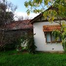
House, 94 Canning Highway, South Perth is representative of the type of housing constructed in the early twentieth century in the Metropolitan region; of the once common practice of localised milk distribution that operated throughout the metropolitan area in the early to mid-twentieth century; and of the residential development of South Perth, and in particular Canning Highway, during the early twentieth century.
A single storey brick, render, and clay tiled building.
The Certificate of Title shows that Samuel Macaulay, well-known Doctor and president of the Y.M.C.A, purchased the property lot in March 1903. It was then transferred a number of times to various private owners after Macaulay’s death in February 1921. The first evidence of the extant House, 164 Canning Highway, South Perth appears in the Post Office Directories in 1930, with a Mr Carrie, Dairyman, listed as the inhabitant. The Certificate of Title reveals that Helen Carrie (wife) obtained ownership of lots 10 and 11 in May 1929. This is also the first evidence of the place being associated with the milk industry. Given that Mr Carrie is listed as a Dairyman in the Post Office Directories, it is likely the house and milk depot building were constructed at or around the same time for the purpose of distributing milk in the local area. The place was likely used as a milk depot throughout the next few decades with Browne’s Dairy Pty Ltd obtaining ownership of the lots in July 1957. It is unclear how long the place was associated with the distribution of milk in the area after this period. Aerial images of the place indicate that the former Milk Depot building was demolished c.2003
Individual Building or Group
| Epoch | General | Specific |
|---|---|---|
| Present Use | VACANT\UNUSED | Vacant\Unused |
| Original Use | RESIDENTIAL | Single storey residence |
| Style |
|---|
| Inter-War California Bungalow |
| Type | General | Specific |
|---|---|---|
| Wall | BRICK | Common Brick |
| Roof | TILE | Other Tile |
This information is provided voluntarily as a public service. The information provided is made available in good faith and is derived from sources believed to be reliable and accurate. However, the information is provided solely on the basis that readers will be responsible for making their own assessment of the matters discussed herein and are advised to verify all relevant representations, statements and information.
164 Canning Hwy South Perth
Cnr Arundel St & Canning Hwy
Arundel Street Dairy
South Perth
Metropolitan
| Type | Status | Date | Documents |
|---|---|---|---|
| (no listings) |
| Type | Status | Date | Documents |
|---|---|---|---|
| RHP - Does not warrant assessment | Current | 28 Oct 2016 |
| Type | Status | Date | Grading/Management | |
|---|---|---|---|---|
| Category | ||||
| Municipal Inventory | Adopted | 01 Jan 2005 | Category E | |
25774 House, 164 Canning Highway, South Perth
Milk Depot was demolished c.2007, see file for images and information.
Historic Site
| Epoch | General | Specific |
|---|---|---|
| Present Use | INDUSTRIAL\MANUFACTURING | Dairy, Butter or Cheese Factory |
| Original Use | INDUSTRIAL\MANUFACTURING | Dairy, Butter or Cheese Factory |
This information is provided voluntarily as a public service. The information provided is made available in good faith and is derived from sources believed to be reliable and accurate. However, the information is provided solely on the basis that readers will be responsible for making their own assessment of the matters discussed herein and are advised to verify all relevant representations, statements and information.
Site
This information is provided voluntarily as a public service. The information provided is made available in good faith and is derived from sources believed to be reliable and accurate. However, the information is provided solely on the basis that readers will be responsible for making their own assessment of the matters discussed herein and are advised to verify all relevant representations, statements and information.
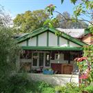
168 Canning Hwy South Perth
South Perth
Metropolitan
Constructed from 1929
| Type | Status | Date | Documents |
|---|---|---|---|
| (no listings) |
| Type | Status | Date | Documents |
|---|---|---|---|
| RHP - Does not warrant assessment | Current | 28 Oct 2016 |
| Type | Status | Date | Grading/Management | |
|---|---|---|---|---|
| Category | ||||
| (no listings) | ||||
• The place is representative of the type of housing constructed in the early twentieth century in the Metropolitan region.
• The place is representative of the residential development of South Perth, and in particular Canning Highway, during the early twentieth century.
House, 168 Canning Highway, South Perth is representative of the type of housing constructed in the early twentieth century in the Metropolitan region; and of the residential development of South Perth, and in particular Canning Highway, during the early twentieth century.
House, 168 Canning Highway, South Perth, comprises a single storey rendered brick and corrugated iron roofed residence, timber framed fibre cement laundry building, and concrete block garage/shed located on Canning Highway in the City of South Perth. The residence incorporates elements of Inter-War California Bungalow. It is asymmetrical with timbered gables and a recessed verandah. The front façade is tuck-pointed face brick over a rendered band to dado height. The side walls are face brick in stretcher bond. The roof is clad in short sheets of corrugated iron and is hipped benind the front facing half-timbered gables. There is a separate skillion roof across the rear verandah. The rear verandah is enclosed by timber framing and fibrocement. A 1.5m high spaced timber fence extends along the front of the property, and there are various plantings in the front and rear. The front door opens to a short entry hall with bedrooms on each side, and the lounge at the end. The interior has timber floors, hard plaster walls, and battened plasterboard ceilings throughout. The lounge has a back-to-back fireplace, surrounded by a jarrah mantel piece. The kitchen and pantry appears to retain the original fitout. The bathroom was renovated in c.1980.
Little development occurred in South Perth between 1829-1833 due to poor soil fertility, difficulty in travelling to and from Perth, and a large area of land being reserved toward the north for the purpose of a village. The establishment of a settlement in South Perth is not evident until c.1837, as shown on a survey by Alfred Hillman annotated by the name ‘Perth Suburban’. The South Perth Roads Board District formed in 1892, comprising the area bounded by Melville Water, Perth Water, Perth-Albany Road, Perth-Fremantle Road, and South Terrace. The first meeting of the South Perth Roads Board was held in the same year. In 1902 South Perth became a Municipality and the foundations of the Municipal Office were laid in 1904. At the turn of the twentieth century, South Perth began to be identified as a ‘fashionable locality’ after it experienced unprecedented development influenced by the gold rush of the 1890s, an influx of people escaping the depression in the eastern states, and following a modest housing boom in the area during the 1880s. Included in this development and contributing to the area’s change of identity was the construction of significant landmarks, such as Perth Zoo. The population in South Perth grew substantially in the inter-war period, with the number of people living in the area rising from approximately 3,000 in 1921 to 9,000 in 1933. Many of the houses constructed under the War Services Homes scheme, the architecture of which was heavily influenced by trends from Europe and America favouring California Bungalow and Old English Revival styling. The Certificate of Title for the land on which House, 168 Canning Highway, South Perth now stands shows that Samuel Macaulay, well-known Doctor and president of the Y.M.C.A, bought the property lot in March 1903. It was then transferred after Macaulay’s death in February 1921. The first evidence of a dwelling at the property appears in the Post Office Directories in 1930, with Charles F. Sabine listed as the inhabitant. Although this coincides with the implementation of the War Services Homes scheme, the research undertaken for this preliminary review could not find any connection. The property has had many private owners and occupiers throughout the twentieth century and Main Roads Western Australia acquired ownership in June 1999 for road widening.
Individual Building or Group
| Epoch | General | Specific |
|---|---|---|
| Original Use | RESIDENTIAL | Single storey residence |
| Present Use | VACANT\UNUSED | Vacant\Unused |
| Style |
|---|
| Inter-War California Bungalow |
| Type | General | Specific |
|---|---|---|
| Wall | BRICK | Common Brick |
| Roof | TILE | Other Tile |
This information is provided voluntarily as a public service. The information provided is made available in good faith and is derived from sources believed to be reliable and accurate. However, the information is provided solely on the basis that readers will be responsible for making their own assessment of the matters discussed herein and are advised to verify all relevant representations, statements and information.
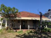
64 Canning Hwy South Perth
South Perth
Metropolitan
| Type | Status | Date | Documents |
|---|---|---|---|
| (no listings) |
| Type | Status | Date | Documents |
|---|---|---|---|
| RHP - Does not warrant assessment | Current | 17 Sep 2021 |
| Type | Status | Date | Grading/Management | |
|---|---|---|---|---|
| Category | ||||
| (no listings) | ||||
No. 64 Canning Highway is a timber framed cottage with fibre cement cladding to the front and weatherboard cladding to the rear and side elevations. The roof is hipped in form and clad with tiles. The roof extends down at the same pitch to form the verandah canopy, which extends across the full extent of the façade, with an additional lightweight canopy supported on steel brackets attached to the verandah posts. The façade is symmetrical in planform with a central recessed entrance flanked by openings. The openings to the east of the entrance has retained the double French doors whilst the opening to the west of the entrance has been blocked up with an air conditioning unit inserted. Despite this alteration the symmetry of the façade remains discernible. The extant French window contains two multi-paned openings with a tapered timber door frame. The blocked up opening has retained the tapered door frame. The main entrance is recessed in a covered porch area and consists of a glazed door with flanking timber and glass side panels. The glazing incorporates Art Deco style leaded motifs. The deck to the verandah and porch is painted concrete slab. The side elevations have weatherboard to the lower level of the elevations and fibre cement sheet cladding to the upper sections. The windows are casements with window canopies supported on timber brackets. The rear elevation presents in an asymmetric form having been extended in the 1980s to add the dining room addition. The elevations are again timber framed with weatherboard to the lower sections and fibre cement sheet cladding to the upper section. Windows to the rear elevation are a combination of sliding aluminium openings and timber framed casements. The rear door opens out onto a small timber deck with steps down to the garden. The garden to the rear is predominantly paved with some mature trees. A shed/outbuilding is located along the western boundary and carport towards the rear boundary. The front garden is lawned with paths to the front door and around the eastern side of the house. There are few plantings. The street boundary is enclosed by high wall whilst the eastern boundary is open. Internally, the house appears to have largely retained its original plan form with the main alteration being the Dining Room addition to the rear of the kitchen. The front entrance opens into a hallway that extends through the house. Bedrooms are located to the east and west sides of the hall to the front section of the house before the hall opens into the Lounge. A further bedroom is located to the east of the Lounge. The rear part of the house contains the kitchen, complete with early cabinetry, a spare room and small bathroom area. The dining room has been added onto the kitchen creating a large open plan space. To the front section of the house are two bedrooms of similar presentation. The floors are timber boards with deep timber skirting. Walls are plastered and painted and the ceilings have ceiling roses and cornice. Internally it can be seen that whilst the French windows to the bedroom to the west of the hall have been boarded up, the French windows have been retained and the alteration is reversible. The lounge is of regular rectangular shape with a fireplace to the south wall, windows to the west and doorway into a further bedroom in the east wall. Access to the rear of the house is also provided. The fireplace has a textured cement block opening which has been painted, and a timber mantel with substantial brackets. Floors are timber with deep timber skirting. The walls are plastered and showing signs of deep cracking. The ceiling has an Art deco inspired ceiling rose. Bedroom 3 located to the centre of the house has the same wall, ceiling and floor treatments as the other rooms. The ceiling is showing signs of damage. The door into the room from the lounge has been removed. There is a further doorway to the north wall which leads into the rear spare room. The kitchen retains much of its original layout and fittings. Cupboards are fitted to all three sides of the kitchen together with the retained fireplace. The floors are timber and walls are plaster. The ceiling has a timber style lining to it. The south, rear, wall of the kitchen has been removed retaining a central post and beam for support. A dining room has been added creating a large open plan kitchen dining area. To the east of the kitchen is the spare room which in turn also provides access into the bathroom along the eastern side of the house. The spare room is a simple space the same finishes seen throughout the house. Windows are timber framed casements and the rear exit door is a flush panel door. Sliding doors in the east wall provides access into the bathroom. The bathroom is a long thin room with basic bathroom fittings the walls are fully tiled and the floor has a linoleum covering.
Individual Building or Group
| Epoch | General | Specific |
|---|---|---|
| Original Use | RESIDENTIAL | Single storey residence |
| Type | General | Specific |
|---|---|---|
| Other | CONCRETE | Concrete Slab |
| Wall | TIMBER | Weatherboard |
| Roof | TILE | Terracotta Tile |
This information is provided voluntarily as a public service. The information provided is made available in good faith and is derived from sources believed to be reliable and accurate. However, the information is provided solely on the basis that readers will be responsible for making their own assessment of the matters discussed herein and are advised to verify all relevant representations, statements and information.